Digital Wayfinding — Overview & Benefits
What is digital wayfinding, growth of 3D maps and kiosks, indoor blue-dot positioning, benefits for large venues, real-world success stories, and IPERA’s Starling platform

Finding your way inside large buildings can feel overwhelming, especially as spaces become bigger and more complex. Digital wayfinding offers a smart, modern solution to this problem. It uses technologies like interactive maps, mobile apps, and kiosks to provide clear, up-to-date directions inside places like airports, shopping malls, hospitals, stadiums, and corporate offices.
Rather than relying on static signs or printed maps, digital wayfinding adapts to your needs by offering personalized routes and information. It makes navigation simpler, quicker, and more accessible for everyone — whether you’re a first-time visitor or a regular guest.
The Growth of 3D Maps and Interactive Kiosks
A standout feature of modern digital wayfinding is the use of 3D maps. Unlike flat maps, these offer a three-dimensional, realistic view of indoor spaces. Visitors can zoom in and out, rotate views, and explore different floors — all helping with spatial awareness in complex layouts.
At the same time, interactive kiosks provide self-service information points throughout venues. These touchscreen stations let visitors search for points of interest, get step-by-step directions, and switch languages if needed. In busy airports, shopping centers, or hospitals, kiosks help reduce waiting times and confusion, leading to a smoother experience.
Many venues have seen happier visitors and fewer navigation issues since installing digital wayfinding kiosks — people feel more confident moving around independently.
Indoor Blue-Dot Positioning and Mobile Apps
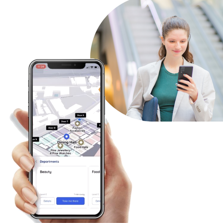
Smartphones have become essential for indoor navigation, especially since regular GPS signals can’t reach inside buildings. Digital wayfinding apps use indoor positioning methods — like WiFi triangulation and Bluetooth beacons — to show your exact location on a digital map, often called “blue-dot positioning.”
These apps guide you with turn-by-turn directions, helping you find the fastest routes inside malls, hospitals, or airports. Whether you’re looking for a particular store, a restroom, or a gate, the app makes navigation as simple as following arrows on your screen.
Extra features such as QR code scanning allow visitors to access maps instantly without downloading anything. This convenience and accuracy significantly reduce frustration and make visits more enjoyable.
Benefits for Large Venues: Airports, Hospitals, and Malls
Larger venues face unique challenges that digital wayfinding can solve:
- Airports: Digital maps and apps help travelers quickly locate gates, lounges, and baggage claims. Real-time updates about delays or gate changes are integrated to reduce stress and missed flights.
- Hospitals: Medical facilities often have confusing layouts. Wayfinding technology guides patients and visitors to departments or emergency rooms, helping reduce late arrivals and confusion.
- Shopping malls: Retailers use wayfinding to increase foot traffic to stores, events, or food courts through personalized promotions. Accessibility routes ensure everyone, including those with disabilities, can navigate comfortably.
In addition to helping visitors, these systems improve operational efficiency, crowd management, and safety during busy times.
Real-World Success Stories
Digital wayfinding is gaining global traction with measurable results. For instance, a major airport reduced navigation complaints by 40% after deploying a combination of 3D maps and mobile apps. One hospital implemented interactive kiosks and saw improved patient punctuality and satisfaction.
Retail centers using location-based marketing alongside wayfinding systems noticed higher visitor numbers and sales at promoted locations. These examples illustrate how digital wayfinding not only simplifies navigation but also helps businesses reach key performance goals.
How IPERA’s Starling Platform is Setting the Standard
IPERA’s Starling Location Services Platform brings together 3D mapping, kiosks, and mobile apps into one cohesive system. Using cloud technology, it keeps data current for real-time, accurate navigation information.
IPERA’s platform offers powerful features like personalized push notifications and detailed visitor analytics, enabling marketing and operations teams to respond dynamically to visitor behavior and needs. Its flexible design fits a variety of industries including healthcare, hospitality, retail, and entertainment.
IPERA leads digital wayfinding innovation by focusing on user experience, security, and practical integration—helping venues become smarter, safer, and more welcoming places.